| |||||||||||||||||||
|
|
Journals 2006/2007Tamara Browning
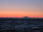
August 27, 2006 I noticed an interesting sunrise this morning. Silhouetted on the horizon was a line of puffy clouds whose shapes reminded me of trees and bushes. Being able to watch the sun rise and set over the ocean was a wonderful experience. Once the sun had risen fully and daylight once again illuminated the watery landscape, I noticed that a large flock of birds had gathered around the ship and were bobbing about on the waves. They had mistaken our vessel for a fishing trawler and were congregating close by in anticipation of an easy meal. Fishermen clean and sort the fish they have caught while they are at sea and throw the innards and by-catch overboard. The birds know this and so follow the boats for an easy meal.
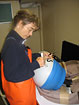
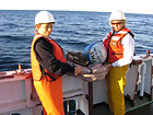
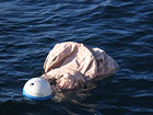
Shortly after 7:00 a.m. we had reached an area in the Gulf of Maine called the Northeast Channel. Jerry had determined that this would be a good site to launch the buoy that he had obtained from NOAA, especially for us teachers. The buoy will drift with the ocean currents transmitting data via satellite for more than a year before its battery runs out. Our students will be able to follow its progress and chart its position by accessing this web site http://osmc.noaa.gov/OSMC/adopt_a_drifter.html. Prior to launch, Karen and I inscribed the names of our respective schools on the surface of the buoy and after posing for photos, we proceeded to launch it by throwing it overboard. The buoy consisted of a plastic sphere that housed sensors and a transmitter and a nylon fabric drogue that helps to catch the currents. For the record these were the launch site coordinates, 42, 14.188 N and 65, 45.937 W and launch time was 7:22 EDT on 8/27/06.
After launch the buoy floated off in an easterly direction into the glare of the rising sun and within seconds was lost to view. A few minutes later though one of the ships officers reported seeing it with his binoculars - a tiny blue and white speck bobbing on the surface way off towards the horizon behind the ship. I hoped that it would function faultlessly and I looked forward to tracking its progress with my students. |
||||||||||||||||||