| |||||||||||||
|
|
Journals 2006/2007Tamara Browning
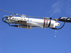
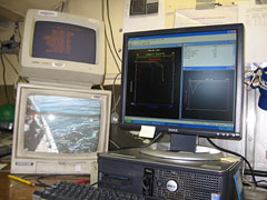
August 20, 2006 A CTD is one of the standard tools used by oceanographers. CTD stands for conductivity, temperature and depth, the physical properties of ocean water measured by this instrument. This CTD we had was a white cylindrical object about the size of two soda bottles end to end, and it was attached to the cable just above the bongo nets. It continuously recorded and transmitted data to a computer in the CTD lab on the ship that displayed these values graphically as temperature, salinity and depth plots.
Jon Hare explained to me that oceanographers use the CTD data to characterize coastal ocean water into different water mass types depending on their location (above the continental shelf or above the slope) and also by its temperature and salinity characteristics. For example water above the continental slope is more salty (34-35.5 ppt) than water above the continental shelf (30-33 ppt) and during the summer months surface water near the shore is warmer deeper shore water. He also outlined one way in which the compiled CTD data from all the sampling sites may be used to understand and visualize changes in the coastal environment. Computers on shore can be programmed to generate maps showing the distribution and relative amounts of the different water masses mentioned above. Jon told me that over the past five or six years coastal water in this area has become noticeably less salty and has been increasing in volume. He postulated that this was due to more fresh water moving down from artic regions further north. Climate change and global warming in the Arctic is known to be causing the Greenland ice sheet, the Artic Ocean sea ice and the permafrost of the Canadian tundra to melt. The melting of these freshwater reservoirs seems to be increasing the flow of the Labrador Current (which originates in the Artic) and changing the characteristics of areas of water in the Gulf of Maine. |
||||||||||||