| |||||||||||
|
|
Journals 2006/2007Tamara Browning
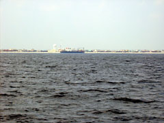
August 21, 2006 This afternoon we could see land for the first time since leaving Woods Hole as two of the sampling sites were very close to the shore. Many of us rushed to grab our cell phones to call home, since these shoreline approaches provided a short window of opportunity where we were within cell phone range. The first sight of land was along the Maryland coast, near to Ocean City and the second shore site was off the coast of New Jersey, by Wildwood. Here the ship was much closer to land and we could see a long strip of sandy beach punctuated by individual buildings. We could even make out the crowds of people enjoying a sunny day on the beach. I felt a pang of homesickness as we steamed on past this point and back out to sea. However, New Jersey left a memento for us as a swarm of nasty biting flies swooped out from the beaches and invaded the ship. The captain ordered all the ship's doors to be closed in an attempt to keep them out. Quite a few of them did get in though, so we brought out the flyswatters (which were conveniently carried on board) and for several days after this a great deal of fly swatting activity took place on board.
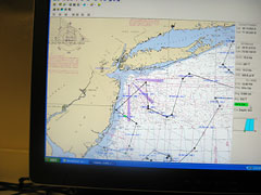
It was easy to follow the course and position of the ship since it was fitted with a GPS aided computerized navigational system. The plotted course and current position were displayed by maps on two computers; one on the bridge for the ship's navigating officers, and the other in scientists working area for use by both scientists and crew. In addition to the map display the program provided information on the ship's speed and direction, its latitude and longitude coordinates and most usefully it calculated the time remaining until the next station would be reached. By checking this figure we could quickly get an idea of how much more free time we had before we had to get ready for more sampling work.
|
||||||||||