| |||||||||||||||||
|
|
Journals 2009/2010Jonathan Pazol
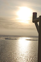
August 19, 2009 When I woke up this afternoon, it was foggy out. People said it was sunny for most of the day, but I don't know if I believe them. Most of the time, the fog has been pretty thick. As we've been heading south and into more open water, the difference in water and ice temperature causes the foggier conditions. I'm told that as we head northeast again and get into thicker ice, we should see more sun. Right before watch, the skies cleared and the sun came out. When people talk about "the land of the midnight sun, they're not kidding." This picture was taken just before midnight.
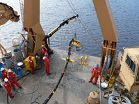
In yesterday's entry, I described the "Chirp" sub-bottom profiler that gives us a cross-section of the sediment floor about 75 meters (245 feet) deep, but there is another method of sub-bottom profiling being used on this expedition, called multi-channel seismic. This too uses sound waves, but because of the greater penetration into the sea floor, is it classified as a seismic system, rather than solely as an echosounding system. Instead of being mounted on the bottom of the ship like the "Chirp" transducers, the multichannel seismic instruments rely on air-guns and streamers that are towed behind the ship. The Louis is using a set of 4 air guns that fire in sync every 20 seconds. The air-guns are lowered off the aft (rear) of the ship by a crane and are connected to a powerful air compressor with long hoses. The compressor is able to fire with a pressure of more than 2000 lbs/in2 and makes a loud "boom."
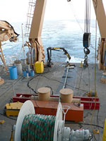
The air guns sit at a depth of about 10 meters (33 feet) and fire into the water to send the sound waves down to the bottom. Once the sound waves reach the bottom, they are able to penetrate the sediment to a depth between 3-4 kilometers (1.8-2.4 miles). The signal is then picked up by a set of streamers - long, fluid filled tubes with hydrophones (sound sensors) regularly spaced inside. These streamers can be as long as 6 kilometers (3.6 miles) and used many at a time, but in the Arctic because of the ice, they need to be shorter and used singly. The one being used by the Louis is about 300 meters (1000 feet) long.
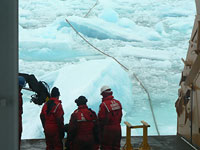
One of the problems with using seismic equipment in the Arctic is the presence of ice. Despite the fact that the Healy is breaking ice for the Louis behind us, the streamers still get banged around by ice chunks or can even be trapped in the ice and lifted right out of the water. If this happens, the streamers need to be reeled back in; however, sometimes they get so stuck that they are permanently damaged or snapped.
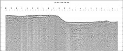
When the streamers record the data and it gets analyzed, it produces a cross-sectional image of the sub-surface to a greater depth than those produced by the "Chirp." Geologists and geophysicists can use this information to find out the actual sediment thickness and the profile of the sea floor. They can gain an understanding of how the features (ridges, depressions, plateaus, etc.) were formed and begin to develop a long-term (millions of years) geological history of the region. The picture below shows a seismic profile on the Chukchi Borderland - one of the areas that we've been mapping. To a trained geologist, it gives a great deal of information about the features, but I am only beginning to understand how to interpret it.
|
||||||||||||||||