| |||||||||||||||||
|
|
Journals 2007/2008Morgan Hardwick-Witman
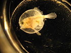
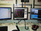
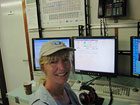
3 August 2007 Location:off Big Pine Key The Florida Keys are low and flat and hover on the horizon, some are green and ringed with mangroves and some developed, most are connected with causeways or bridges. Typical day is up by 7 am and the first nets in the water before 7:30 and we usually finish the last station between 5-7 pm. Choosing the sampling sites becomes more interesting as arrays of lobster buoys appear up ahead with lobstermen setting out new rows of traps. We are near Looe Key Management Area (a protected area). Protected is often loosely interpreted. Only ~0.1% of our ocean is being protected. We need to really protect much more of our oceans if we are to conserve our marine resources. If you are onboard a vessel and don't know what to do, find your way up to the wheelhouse and you can learn a lot. Captains are a wealth of information, and they have amazing technological tools, if they aren't maneuvering in a tight situation, they are often willing to show you something really interesting. I was in the wheelhouse while Chief Scientist Bob and Mate John were looking for the Gulf Stream to locate our offshore sampling sites. I'm learning that locating these sites, though mostly science, is part art as well. We were looking for ~2 knots of current but settled for a current flowing in a more parallel direction than that of the middle stations where the current flows were bending back towards the shoreline. John was describing how to locate the ships on the radar screen as we tracked the speed, distance and even their cargo. I watched the data returning from the CTD scan with interest as I looked over graduate student Joel's shoulder, as he sat at the command station talking via head phones to the captain and 'firing' the bottles. Meaning he decided the water depths at which the water collecting bottles would be filled. Four lines filled the colorful graph on the computer for the temperature (blue), salinity (red), oxygen (green) and pink for the fluorometer, a measure of productivity, of the ocean water. The measurements were taken from the ocean surface to about 100 meters. We looked over the side through the clear blue waters to see how deep we could see the CTD as it quickly descended. We lost sight of it at ~34 meters. Ok, now how deep is that in feet? Took one lousy and one okay photograph of a plump batfish larvae under the microscope. I think I need to read the new camera manual. We will learn about ISIIS tomorrow stay tuned...
|
||||||||||||||||