| |||||||||||
|
|
Journals 2006/2007Miriam Sutton
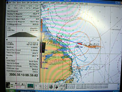
August 9, 2006 AM Location: Hamilton Spur (54° 49' 35.24" N, 52° 43' 30.67" W) What a beautiful day at sea! The high seas continued to abate overnight and by sunrise, the sea height had been reduced to a gently pulse from distant sea swell. I've asked the crew when the flat calm days will arrive and they haven't responded too promisingly. The CO responded that, "there's a lot of ocean that affects the Labrador." Any storm in the Atlantic or in the Arctic tends to send swell to the Labrador. Today's calm seas made for easier coring today and the scientists and crew were able to obtain three more 40 - 50 foot core samples from three locations along Hamilton Spur. The seismic data collection also continued throughout the day. Tonight the CCGS Hudson is following the navigation chart toward a site known as Makkovik Bank which is a few miles offshore of the Labrador coast. (See Navigation Chart photo below.) The depth sounder is also indicating shallow coastal waters and our seismic data collection has been minimized for the next 12 hours. Seafloor conditions in coastal and near-coastal waters are much better known than the deep-sea regions we have been exploring offshore.
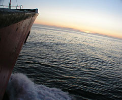
As I was preparing for my night shift, I took few moments to walk along the deck of the ship and enjoy the evening approaching from the west. The sun appears much brighter and more intense in these higher latitudes as compared to 20 degrees farther south. The intensity faded as the Sun sank toward the horizon and I took the opportunity for my first sunset on the Labrador Sea. (See Sunset photo below.) What a beautiful evening on the water! This is why I go to sea.
Today's activity: Use a globe to observe and discuss possible reasons why the Sun appears more intense at higher latitudes (like the 54° latitude of the Labrador Sea) as compared to the lower latitudes (like the 36° latitude of North Carolina). Word of the Day: Navigation Chart REMINDER: Record today's Sea Surface Temperature (SST) and the Air Temperature on the data table you created from the August 05 journal entry. |
||||||||||