| |||||||||
|
|
Journals 2006/2007Miriam Sutton
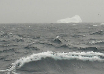
August 7, 2006 AM Location: Orphan Spur (51° 11' 35.17" N, 49° 19' 20.87" W) Ok, so maybe it was actually a couple of miles off the starboard bow, but it was definitely an iceberg. It was shrouded in a mist of fog that had lingered through the night, but the sun was making a valiant attempt at revealing its beauty. I watched in amazement as the giant waves crashed along the base of the ice giant. (See "Iceberg" photo below.)
The CCGS Hudson reduced her speed to 4.5 knots to collect seismic data along a missing section of Orphan Basin in 1500m. This data set will be added to the remaining data set that is already on ready and will provide scientists with continuous seismic data from Orphan Basin to Hudson Strait. During my night shift (8PM - Midnight), the ship's bridge (AKA: where they steer the ship) notified us that the radar indicated several icebergs lying in our transect path. The decision was made to modify the transect path and divert our course around the icebergs. During the discussion, concerns were also raised about "bergy bits" that might lie hidden beneath the surface. Bergy bits are remnants of icebergs that have become totally submerged just below the surface. They are often too low in the water to be detected by the radar but are still large enough to cause ship damage in contact. The slow speeds the ship is maintaining for our research will certainly assist the crew in spotting these stealthy bergy bits. I tried to retire my concerns for a bergy bit collision as I fell into my bunk for the night. As the seas continued to build through the night, my concerns about bergy bits faded as various items my roommate and I had stored on an open shelf began to fly across the room. Each time the ship pitched hard to starboard, another shampoo bottle or hairbrush followed the momentum across the cabin. What a night! Today's activity: Freeze some water using odd-shaped cookie cutters placed on a pan in your freezer. (Three-dimensional shapes work best.) Once frozen, remove the shapes and cut them in half using a diagonal cut across the shape. Place the shapes in a large container of water and observe the changes in the center of mass for each "iceberg." Record your observations and discuss with a friend what caused the "iceberg" to tilt and flip over as they continued to melt. Word of the Day: Stealthy REMINDER: Record today's Sea Surface Temperature (SST) and the Air Temperature on the data table you created from the August 05 journal entry. |
||||||||