| |||||||||||
|
|
Journals 2006/2007Miriam Sutton
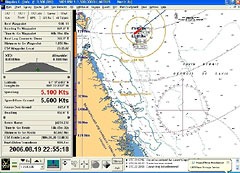
August 19, 2006 AM Location: Slope off the Hudson Strait (61° 41' 14.05" N, 60° 28' 18.69" W) We crossed the 60th parallel during my night shift last night. It isn't the Arctic Circle but it is as far north as I've ever been. The ship continued northward after my shift was over and when I awoke this morning, the crew was setting up the corer for sampling sections of the continental slope outside of the Hudson Strait. We're collecting 3 or 4 cores today and the scientists are looking for signs of sediment outwash that may have traveled from Hudson Bay, through the Hudson Strait, and deposited on the continental slope outside of the strait. The red "ship" shown in the navigation chart below indicates our current location to the right of Hudson Strait. (See Navigation Chart below.)
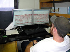
The seismic team is continuing to monitor two of the instruments during today's coring. I talked with one of the scientists last night about the comparisons made between the seismic data and the coring data. The scientists can actually compare the graphic and digital images of sediment layering created by the seismic equipment with the sediment layers collected during coring in the same location. These comparisons can validate the seismic data as well as the coring data. As an example, our seismic data may indicate a substrate of sediment that appears to be less densely packed than mud. The seismic images may suggest a layer of gravel deposited between several layers of mud. If cores are taken in the same section of seafloor, the scientists' hypothesis can be tested and confirmed. Coring serves as a type of ground truthing for the seismic data. (See Digital Seismic photo below.)
Today's Activity: Practice some ground truthing in your neighborhood. Use a road map to locate the vicinity near your home and school. Using the map's mileage scale, record an approximate distance from your house to the school. Check the odometer of your car when you leave home and when you arrive at school. Compare the actual mileage driven with your car to the estimation you recorded using the road map. How does driving the actual distance provide ground truthing for your estimation? Word of the Day: Validate REMINDER: Record today's Sea Surface Temperature (SST) and the Air Temperature on the data table you created from the August 05 journal entry. |
||||||||||