| |||||||||||||||||||
|
|
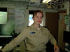
Journals 2006/2007Elaine Paulishak
July 25, 2006 This was a unique day because it started out sunny and stayed sunny all day. The Fairweather again continued to do survey tracks all night and according to the "Plan of the Day," surveying would continue until 1100 hours and then the ship would get underway for its final destination: Dutch Harbor. each day the FOO, that's the Field Operations Officer, would post the plan of the day after it was signed by the XO (executive officer). The FOO is the person who schedules and keeps track of all operations on the ship, including but not limited to: what launches would be deployed, who would be steering the launch, what scientists and techs would be needed, what hours would they be engaged, coordinate with the galley crew to have lunches packed, etc. This is only a small list of many duties that the FOO's job entails. At the same time the ship survey schedules and who would be doing them must be taken into consideration, along with who may need to be diving to check the hull and who will run the emergency boat to make sure it is working properly. Machinery is constantly being checked and maintained on the ship. At the same time, the FOO has to be very flexible because various circumstances that may be out of anyone's control. For example, weather may cause the Plan for the Day to be changed. We had already experienced that. Rescheduling had to be done. The job of Field Operations Officer on the ship is quite a challenging position. It takes quite an extraordinary person to fill this position and still maintain a sense of humor.
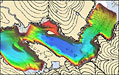
Speaking of schedules, everyone on the ship has their watch or duty schedule. There are schedules for meals: Breakfast - 0700-0800, Lunch 1200-1230, Dinner 1700-1730 and be prompt. The food was always excellent and in case you don't make it to a meal, snacks and fruit were always available. In the plot room, field processing was taking place and once the data was cleaned and correctors are applied; three dimensional digital terrain may be generated, which are colored by depth.
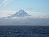
So on this beautiful sunny Tuesday, the plan was going as scheduled and we were headed toward our final destination in Dutch Harbor, which is located across a bridge from the town of Unalaska, Alaska. On our way we passed islands with large volcanoes which were quite impressive.
We were traveling along the Aleutian Island chain which is part of the Ring of Fire; area of active volcanoes and earthquakes. The Aleutians lie between the Pacific and North American tectonic plates. The great majority of the islands bear evident marks of volcanic origin. The coasts are rocky, the approaches are exceedingly dangerous, the land rises immediately from the coast to steep, bold mountains. There is so much interesting history and geography to learn about the Aleutian Islands (go to: http://en.wikipedia.org/wiki/Aleutian_Islands for more).
Our estimated time of arrival was 0800 at Captain's Bay on Wednesday, July 26, and it appeared that we would make it. |
||||||||||||||||||