| |||||||||||||||||||||
|
|
Journals 2006/2007Elaine Paulishak
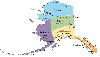
July 18, 2006 The mission of this expedition, otherwise known as the "Plan of the Leg" was to collect hydrographic data to update nautical charts of the Shumagin Islands. The ship, the Fairweather would transit from Kodiak Island, along the Aleutian Island chain to where the Shumagin Islands were located. After collecting sonar data, we would continue on to our final destination and dock at the port of Dutch Harbor, Alaska.
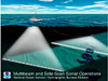
The Fairweather has two multibeam echosounders mounted on the bottom of the hull toward the bow. A Patch Test of the 8160 needed to be done. The RESON SeaBat 8160 is one of the multibeam echosounders used for deep ocean surveys. A Patch Test is related to what we commonly refer to in science class as calibrating the instrument; making sure that the tool is zeroed and functioning properly. A second echosounder, the RESON SeaBat 8111 is used in areas up to 400 meter ocean depths. In nautical terms, ocean depth units are in fathoms in U.S. deep waters. In U.S. shallow water the depth unit is in feet. One fathom is equal to 6 feet or approximately 1.8 meters. In other countries, such as Canada, Britain, etc., the charting is done in meters. Velocity is often designated in terms of knots. A nautical mile is equivalent to 1.15 statute miles. One knot equals one nautical mile per hour. Knots are the units used for the speed or velocity of ocean going vessels. The average speed of sound through water is approximately 1,500 meters per second. However, there are a number of factors to be discussed that affect the speed of sound through ocean water.
SONAR (SOund Navigation and Ranging) is based on the characteristics of how sound travels through water. A pulse is sent out from an instrument called a transducer. The pulse moves through the water and bounces off the seafloor or other objects in the water. The time it takes for the sound pulse to return is recorded. Knowing the speed of sound through water is required to determine the depth of the ocean bottom. Using this data, the ocean topography may be mapped and used to update nautical charts. The Fairweather uses multibeam technology which allows data to be collected at many points along a swath over designated lines or track areas. A multibeam sonar produces a swath width area which is dependent on the depth of the water. Deeper depths produce a wider band of area.
However, before the raw data (i.e. the time it takes for the pulse to reach the bottom and reflect back divided by two to compensate for traveling in two directions) can be useful, there need to be tests done for accurate determination of the speed of sound through sea water. The speed or velocity of sound waves is directly affected by density. Salinity, temperature and pressure affect density. For example, sound travels faster through more dense water since molecules are more closely packed together. Greater salinity means more salt is dissolved in the ocean and adds to ocean density. The salinity of ocean water is determined by conductivity testing since salt water will conduct electricity. As temperature increases, the sound speed increases by 3 meters per second for each degree Celsius. Sound speed changes by about 0.017 meters per second for each .1 ATM of pressure. How do the scientists and technicians correct for sound speed? One of the instruments used is called a CTD (Conductivity, Temperature, Depth) probe. It is deployed to sample water and provides the needed data to produce a sound velocity profile which will then be used as a corrector on the data from the sonar readings.
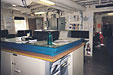
Correction must also be made for tides. As tides go in and out, the depth of the water level obviously changes. Shallow or coastal areas are extremely affected. That is another part of the crew's job, setting tide gauges where needed and then checking them periodically to verify the tide levels. On nautical charts, the MLLW (Mean Low Lower Water) datum is the reference level. Once hydrographic data is acquired by the computer, it must be verified and processed. This is done by hydrographic scientists and officers on the ship. Next it is sent to the branch office for processing and then new nautical charts are generated.
For more information on science of sonar and sound go to: http://www.dosits.org |
||||||||||||||||||||