| |||||||||||||||||
|
|
Journals 2006/2007Elaine Paulishak
July 24, 2006
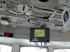
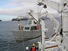
The anchor and chain was in place before 0800 at which time there was a safety meeting for all personnel involved in the day's activities. I was included because I would be going out on launch 1018 with the survey crew to accumulate data closer to the islands. Fairweather has two survey launches which are designated by numbers. Each twenty nine foot launch has a transponder mounted to the bottom of the hull.
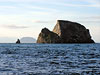
There were a number of survey areas around the Shumagin Islands that needed to be surveyed on this trip. The launch is used for shallower areas often near coastlines where the depth is problematic for the ship to survey. As we reached each area, the transducer could be lowered and the boat was maneuvered to cover the survey track lines.
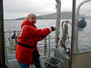
The CTD was lowered to get the readings the conductivity, temperature and depth. After the CTD was pulled up, a cord from the instrument was connected to the computer onboard and the data was transferred electronically. This was quite an experience, especially if one thinks of being on the ocean in a "motor boat." The seas were not extremely rough but enough to make the ride bumpy and choppy and I enjoyed it. At each location that needed to be surveyed, we established a pattern: lower the transducer, survey the designated area, determine if the data was being recorded correctly by the onboard computer, deploy the CTD, retrieve the CTD, transfer the data from the CTD to the computer, the transducer was retracted and then we ventured to the next area.
Meanwhile, we received a radio message from the ship, that they were going to raise the anchor at 1400 and proceed to their next survey area. We would be picked up on the way! It was a cloudy rainy day but we were lucky, the seas were not too bad. As we approached the ship, I heard the CO indicate that the ship had been brought to a stop. Our launch was steered alongside where it was attached to a hoist and we were lifted up to the D deck where we got off. It turned out to be quite a productive day and we even made it back in time for dinner at 1700 hours.
|
||||||||||||||||