| |||||||||||||||
|
|
Journals 2006/2007Anna Hilton
August 18, 2006
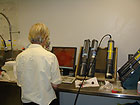
What happens to the sample and sonde data collected in the Tidal Creeks Monitoring and Assessment Project? Susan Lovelace, Educational Coordinator at Hollings Marine Laboratory helped me put the pieces of the puzzle together. The sonde data is downloaded into the computer data base at HML. I had worked with Ann Blair and Travis Washburn in the lab after the Sapelo sampling trip, so I was familiar with the procedures for downloading the data from the sondes onto the HML data base. Ann and Travis talked about any outlying data. Outlying data means measurements that were much higher or lower than normally recorded. They tried to make sure any outlying data did not show up because of faulty equipment or problems in the field.
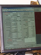
The valid data is then entered into a HML data program designed by David White, Ph.D. This is an exciting and inventive new data program being developed at Hollings Marine Laboratory. The data from the Tidal Creeks Monitoring and Assessment Project, and also data from other HML partnership research projects will be entered into a semantic map. The semantic map will connect related data from many research investigations with the click of the mouse! This connectivity will help scientists, government officials, and community planners to answer the complex problems that face our marine environment.
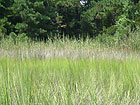
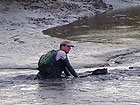
There is one last question to be answered. What is the best way to travel through the pluff mud in the tidal marsh? I discovered in my investigation to look at the color and height of the Spartina to avoid the deeper pluff mud; to step quickly through it; and (if stuck in the mud) to swim or crawl out of it on hands and knees. I have always thought that pluff mud shoes shaped like paddles might really work for walking in the salt marsh. Could you be the scientist who invents a new tool to use in the Tidal Creeks Monitoring and Assessment Project?
|
||||||||||||||