| |||||||||||
|
|
Journals 2008/2009Roy Arezzo
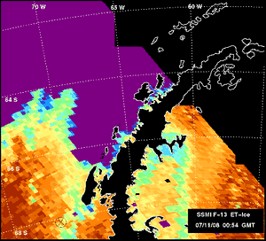
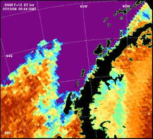
July 13, 2008 Today I started adjusting to my watch schedule and ate a late breakfast, hit the gym and showered before lunch. I started working around noon and stayed up until 2 a.m. in preparation for my 12 to 12 shift, which will start once we reach our first study site. Of course when we reach our first study site has more to do with ice conditions than the will of the scientists. We are approximately 32 hours (over 300 miles) away from our first station. To be prepared for arrival and anticipate schedules for sampling at each site we monitor the ice conditions and distributions. Since it is winter and the sea ice is getting thicker by the day we will go to our furthest south study site first by Marguierite Bay to work in the coldest waters of our transect in an attempt to beat the freeze. Generally the further south we go and the more time in to winter season, the more ice. However the exact location of ice sheets can vary day-by-day based on currents and winds. Although the ship is well equipped to break through ice, it certainly slows things down a great deal. Chief Mate, M. Sebastian Paoni, has been on the NBP for several years and recalls the NBP breaking through small bridges of 6-8 meter thick ice (24 feet!) but this A-2 Class Icebreaker vessel is generally rated for 3-foot thick ice at 3 knots.
The preparations continue and we have had several science orientations today on how to work the various instruments. The camera frame continues to be tweaked and batteries have now been added. We also spent a fair amount of time creating labels for all the anticipated samples and discussing where they will live until the end of the cruise when it is time to pack them up. Since some samples will be analyzed onboard and others taken to various labs, labeling, logging and proper storage of all samples is very important. In a 24-hour operation it is not possible for one person to be in charge of all log books, so all of us need to know where to put things and how to label them probably. At 19:00 hours I got a dry run with Megacore sampling chamber. It will not be long before it is pulling up mud from 600 meters down. Some of the cores will be preserved in formalin, some cores will be sliced at centimeter intervals, whereas other core samples will be frozen at negative 20 degrees Centigrade. I ended my workday at midnight and saw my first sea ice. Temperature outside is around 29.5 degrees F (- 1.4 degrees C) but the wind chill is 5.36 degrees F (- 14.8 degrees C). The water is now relatively flat with gentle swells. The "pancake ice" carpets the surface with bluish-white, one to three meters in diameter oval shaped ice floats. I went out on the bow and with ship's floodlights I was able to see miles of ice around the boat, it was surreal and reminds me how special a place this is. |
||||||||||