| |||||||||||||||||||
|
|
Journals 2008/2009Jeff Lawrence
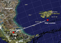
December 30, 2008 The Falkland Islands are also known as the Islas Malvinas and is an archipelago in the South Atlantic Ocean, located about 300 miles off the southern coast of both Argentina and Chile. They are really two main islands know as East and West Falkland and are surrounded by many small islands. Port Stanley on East Falkland is the capital and they are a self-governing territory of Great Britain. However the Argentines have made claims to the Falklands for many years. In 1982 Argentina invaded the islands which began a two month long war between Argentina and Great Britain. The Argentines soon withdrew from the islands and England keeps a well-supplied Naval presence on the islands. Fishing and tourism are the two main forces that drive the economy of the Falklands. The main use of the island itself is pastureland for over half a million sheep. Sheep outnumber the people with only about 3,000 permanent residents on the island the Falklands are sparsely populated. Last night several people spotted lights near the coast of the Falklands. A big deal when you have not seen land in 25 days. Our destination after we finish here tomorrow is Punta Arenas, Chile where all the samples and equipment will be loaded off the ship and sent back to the labs.
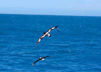
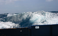
Last week we were on the north side of the islands and the temperature outside was much warmer. The CTD showed a surface water temperature of about 7°C, which is very cold. When the wind races across the ocean the temperatures out on the deck is much colder. Today the skies are mostly clear and it is sunny, but as soon as you step out in the wind you feel winter cold temperature instead of warm summer breezes most of us would be accustomed to in the middle of summer. Today the seas are very rough, with swells running from 10-15 feet. Every now and then a larger swells hits the ship causing a little discomfort and some reorganization of things not tied down. In seas like this you find out quickly what is secure on the ship and what it not. The swell below may not look overly impressive in the photo, but it is actually about 18' higher than the regular ocean surface on a calm day at sea. The wave is large enough to cause some discomfort but it will not stop operations on the ship. We have a CTD deployment in about one hour and will put it in the water with care. On days like today we put the CTD in the water a little differently that on a calmer day. If seas get much worse than this as they did on December 21st, operations on deploying instruments off the boat will cease, which has only happened once on the entire trip. The daily OCP that happens off the fantail of the boat was cancelled earlier due to the rough seas. Yesterday I saw several penguins making their way through the rough seas toward land. Penguins are well adapted to this type of weather and glide through the water like miniature dolphins.
Questions of the Day:
|
||||||||||||||||||