|
|
Journals 2008/2009
Steve Howard
Meadowdale Middle School, Lynnwood, Washington
"Seafloor Mapping in support of the Law of the Sea
U.S. Coast Guard Cutter Healy
August 12, 2008 - September 5, 2008 |
 |
 |
Journal Index:
August 12 - 13 - 14 - 15 - 16 - 17 - 18
19 - 20 - 21 - 22 - 23 - 24 - 25
26 - 27 - 28 - 30 - 31
September 1 - 2 - 3 - 4 - 5
|
August 21, 2008
Birds-eye View
Current position: Long: 156 23.595 W Lat: 83 1.246 N
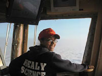
Woke up to a sunny morning. A thin layer of clouds was struggling to keep the sunshine at bay, but you could see it was a losing fight, and we had bright sun all day. I took in some good ice-watching time at the bow, which has become somewhat of a morning ritual, and then climbed the three flights up to the bridge to see what was going on up there. There are always one or two crewmembers up there, and they are generally happy to chat about what they do on the ship. The bridge is a quiet and peaceful place, and is quickly becoming one of my favorite places to pass time and watch for wildlife. I haven't seen any more that a few fish so far, which surprises me as I'd heard so much about the "rich diversity" of the Arctic waters. We are very far from land, though, and the water is deep here, generally 3000 meters or more, so that may be part of the reason why we haven't seen more birds and marine mammals. Everyone is constantly on the lookout for polar bears, and I have been told that if someone spots one to contact the bridge and they will announce it over the PA system.
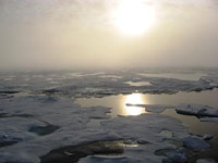 |
Morning sunlight on the Arctic ice |
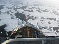
Above the bridge there is a tower called the "Aloft con," which is where someone pilots the ship. I ventured up a series of three ladders which, gets you up to the top, and had a look around. Boy, you think you have a great view from the bridge and then you get up there... incredible. The space is quite small, but there is a narrow deck that goes all around and you get a birds-eye view of everything. I can see why one would steer from up here, because you can see for miles ahead and pick out and follow the watery channels between the ice, called "leads," and avoid the thicker ice pressure ridges that tend to slow you down and consume expensive fuel. It's a great spot, and I'm looking forward to making more visits up there throughout the trip.
 |
|
 |
View from the Aloft Conn |
|
Coast Guard ENS Tasha Thomas piloting the Healy |
PROFILE:
David Skillicorn, who is also my roommate on this expedition, is an award-winning documentary filmmaker who has been contracted by NOAA to take footage of the mapping research and conduct interviews of the key scientists involved. After editing this footage, David will send it on to NOAA who will in turn send it out to the major network news organizations. It is an indication of the high profile of this Arctic seafloor mapping work that David is here documenting this process. David suspects that this footage will be seen by millions over the network news in the coming months. David has been doing documentary filmmaking for the last 30 years, working with the major networks (CBS and ABC) until the last ten years when he moved into independent work. His filmmaking has taken him to over 30 countries across five continents, focusing on the more serious stories through social documentary. His approach is to "go in with an open mind, learn what you can, and tell about it in an interesting and intelligent way." David feels fortunate that he began working with video at its infancy, and is impressed by the explosive growth of video production accessible to the general public these days over the internet and with personal computers and a basic video camera. David said that he is thrilled to be here and to get a chance to experience this amazing landscape and the scientists working here. If you would like to see more of David's work, check out his website at www.sunrisemedia.org.
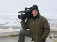 |
David Skillicorn filming the Healy expedition for NOAA |
|
|


