| |||||||||||||||||
|
|
Journals 2007/2008Megan O'Neill
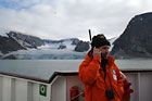
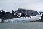
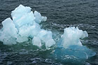
August 16, 2007 This morning I worked the last shift of the first Arctic Expedition for the B.I.O. Hesperides. We continued to map the ocean floor at the southeast tip of Svalbard. We were located at 76°15'N and 17°18'E at a depth of 300 m. At the end of our shift, the ship headed towards the fjords south of Longyearbyen to allow the film crew to get some views of ice and glaciers. The only scenery that we been exposed to was essentially water, so they wanted to include some photos of the "real" Arctic landscape! We arrived there about 13:00 and it was beautiful! The glaciers were incredible and the cracking/gurgling sound of the icebergs melting in the water was unlike anything that I had ever heard before. That sound was something that I had not expected and I tried to capture it on video. I don't know if it will do it justice or not, but I hope to share it with my classes - the sights and the sounds. At 15:15, Angelo and I went up to the bridge with the satellite phone provided by the National Science Foundation and attempted to call my class. Mrs. Hannon, Mrs. Ayers and Mrs. Garrick had been communicating with me earlier in the week to be able to coordinate this effort to allow Angelo to personally explain to the students our expedition and his background. I was ecstatic to talk to my class! It was so neat to be so far away and in such a remote area and still have contact with them! It was also wonderful to have the backdrop of the glaciers behind us, as Monica videotaped it for me. The first attempt was unsuccessful, as we lost our signal within the first few minutes. We called back and tried again and were successful this time. Angelo is an expert communicator and was able to explain the different types of glaciers, how they form and the type of work that he does. He was able to word it so that anyone could follow it - that is the key to spreading scientific work - being able to inform the general public of the technical work in a format that is understood. It was great! I am so glad that I caught it on video as well, so I can share it with classes in the future. Tonight we had appetizers that were brought from Barcelona to commemorate our expedition, which included ham and different types of meats. Angelo presented a PowerPoint with a summary of all of the data that we have collected during our trip. It was interesting to see the 3-dimensional images that the scientists put together from the TOPAS images, Multibeam and Seismics. From those images, they could make conclusions about features that were recognized on the seafloor such as ice streams and glacier movement. The micropaleontology also indicated preliminary evidence of organisms that were indicative of the geologic time periods expected. This will be confirmed once the samples get back to Salamanca to be studied further. I could not believe that we had almost reached the end of our expedition and that we would be in port in the morning! Exciting and sad all at the same time!
|
||||||||||||||||