| |||||||||||||||||||
|
|
Journals 2007/2008Janet Miele
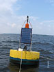
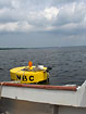
July 20, 2007 Today I arrived at MERLE to meet the three man crew of the DEM boat. We would be going out to check three of the fixed buoy stations in Narragansett Bay. These three stations belong to a network of sites that transect the length of the Bay. This network currently consists of 13 active stations that are fitted with instruments that collect water quality data every fifteen minutes. Most stations are seasonal and operate from early spring until late fall. The buoys are hauled out in winter and stored. The data from the buoys is transmitted to on-shore computers where scientists analyze the data. This data is used to analyze the overall quality of water in the Bay which is required by the federal Clean Water Act. This data is also available to the public and available at the DEM website (http://www.dem.ri.gov) During the summer months, DEM assists the hypoxia study that Leslie is conducting by collecting water samples from selected stations that are taken back and analyzed at MERL. Today's trip was to the Quonset Point, Bullocks Reach and North Prudence sites. One of these buoys had stopped transmitting Sonde data so this buoy would have to be looked at carefully.
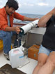
On today's cruise we would be checking the three buoys and collecting water samples and real-time YSI Sonde data. Since the weather was a bit overcast when we put in at Allen's Harbor, we were optimistic that the weather would hold allowing us to complete the assigned tasks. We would also be spending some time doing some routine maintenance on each of the buoys we hoped to visit. Additionally, the Sonde in the Quonset Point buoy had stopped sending data so it would have to be removed and checked. When we arrived at this first stop, the Sonde that was removed had some corrosion surrounding the sensors and so did need replacing. Heather connected a new Sonde and placed it in the buoy. To collect the real-time data and water samples, each of us would have a job. Edwin would collect the water samples using the Niskin bottle and then transfer the water to a carboy using a large filter that he had engineered. Samples had to be collected 1 meter from the surface and 0.5 meters off the bottom and placed in appropriately labeled carboys.
Heather and Taylor would use another Sonde to collect data every half meter until they were 0.5 meters off the bottom. As Heather lowered the probe to the appropriate depth, Taylor would record the readings for dissolved oxygen, temperature, salinity, fluorescence, pH, and chlorophyll. After we had finished our collections the temperature measurements would be called into Leslie back at the lab so that she could set one of the light box water baths to that temperature to incubate the dissolved oxygen samples from this site.
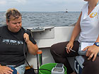
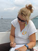
My job would be lowering the light meter every half meter going down to 0.5 meters from the bottom and then once again every half meter going up to within 0.5 meters from the surface. As I lowered the meter to the appropriate depths, Heather was recording the meter readings on the data sheet for this site. Once again, this team was very efficient so that we had completed our readings, sample collection and buoy maintenance in about forty minutes. By this time, the sun had come out and it was a beautiful day on the Bay. We were on to our next buoy where we would repeat this process. As we worked, Heather explained that DEM maintained only a portion of the buoys in the Bay. Other agencies such as the Narragansett Bay Commission, Roger Williams University, and the Narragansett Bay Estuary Program fund and maintain the other buoys and near shore stations attached to fixed structures such as docks. DEM acts as the coordinating agency for this network. Each station is located strategically to serve as an early warning indicator of changing conditions. For this reason, there are more stations located in upper Narragansett Bay due to the presence of wastewater treatment facilities and large tributary rivers such as the Blackstone and Providence Rivers that have the potential to greatly affect the water quality in the Bay.
After servicing our third buoy, we headed back to Allen's Harbor. I was amazed how quickly Heather floated the boat onto the trailer and out of the water. Working as a boat driver for a state agency requires special certification. Heather had completed her certification while working in Tampa, Florida. She was required to even take a "behind the wheel" cruise to gain her certification. After tying down all the equipment and the boat, we were on our way back to MERL where Leslie and her crew were anxiously waiting for the water samples. It took another couple of hours to process and fix all of the samples. It had been a busy day but the time spent out on the Bay was amazing. Because of the glitch in the cruise schedule for this week's samplings, we would have to come in on Saturday to complete the testing protocols. Since Hannah had a previously scheduled weekend trip, Leslie invited me to take her place and run the dissolved oxygen assays and set up the chlorophyll filters. How could I refuse such an energetic group especially since I was actually becoming adept at using the spectrophotometer. |
||||||||||||||||||