| |||||||||||||||||
|
|
Journals 2007/2008Mark Goldner
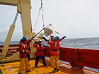
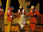
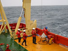
November 19, 2007 57° 30' S 63° 49' W We are certainly feeling the cold winds coming off Antarctica as we get closer to the frozen continent! We even had a little snow today. The seas were very very rough last night and this morning. For the first time I began to feel a bit seasick. I guess I don't need to feel too bad since the seas at times were filled with swells well over 15 feet! A dose of Dramamine and a glass of coke seemed to do the trick. When things are rolling around like that, you begin to do everyday tasks more carefully. When washing up last night before bed, I had to think about where to place my soap so it didn't fly onto the floor! Taking a shower this morning was a little adventure - I had to hold on most of the time or I would fall down. Even walking down the hall is a new experience. You definitely feel the rolling of the boat more in the front than the back. Unfortunately the mess hall is up front. It's interesting to eat a meal while your stomach is feeling fluttery from the up and down. You also have to pay attention to where everything is so your plate and glass don't slide onto the floor. But we still continue to have excellent food - I'm amazed at how the cooks can prepare so much good fun under these conditions! Some great news today - if we continue to stay on our present course and don't run into too many difficulties, we may be able to make a stop at the Northern tip of Antarctica for Thanksgiving!! I just came back inside the lab after helping to deploy our 28th "CPIES". If you've been reading this blog, you've heard reference to a CPIES. What, exactly, is this CPIES thing anyway? CPIES stands for "Current and Pressure measuring Inverted Echo Sounder". This device, invented by Dr. Randy Watts at URI, is used to find the "temperature profile" of the water. The temperature profile is a picture of what the range of temperature is from the sea floor to the surface. By finding the temperature profile of the ocean in several places, you can infer what the ocean currents are doing over time.
So the CPIES uses a clever technique to find the temperature of the water. The basic idea is that sound travels faster in warmer water than colder water. By sending a short sound through the water and listening for how long it travels, you can infer the average temperature of the water. (Also, oceanographers use logs of known "temperature profiles" from many previous experiments to infer the temperature profile - where it's colder and warmer, for example.) The way the CPIES works is that there is a sound producing device (called an acoustic transducer) that sends a very loud pulse (at 12kHz, for those who might want to know - sounds kind of like a cricket). It then waits until the sound reflects off the surface of the water and hits the transducer again. Based on the time it takes for the sound to return, the oceanographers can determine the density and therefore the temperature of the water. (It takes the sound somewhere around 5 seconds to make the round trip in 4,000 meters of water, or around 13,000 feet.)
The sound producing device is called the "IES" part. That's anchored to the bottom of the ocean by a round steel frame and two 50-pound weights. Inside the white plastic case is a glass sphere with all the electronics, a computer, and batteries. That glass sphere is kept at low pressure, which helps keep it well sealed and protected. So before the device is packed up, it's hooked up to a vacuum pump to take air out. Also attached to the device, floating about 50 meters above the CPIES (that's ~150 feet), is another device that measures the water current and pressure directly. That's the "C" and "P" part of the device. You'll notice in the pictures a black cable. That cable transmits data to the "IES" part.
The experiments we're starting now are going to last 5 years. In 5 years, the team will recover all their devices. The way that works is that a signal is sent down to the CPIES to release itself from the anchor and then it floats to the surface. On its way up it is sending out a sound signal. When it hits the surface, a light begins to flash. That's how the ship can make sure it gets near the device to pick it up. Actually, I got to witness a couple of recoveries already. Two of the CPIES devices were malfunctioning and had to be sent back up to the surface. The scientists knew this because the signal they received from the CPIES wasn't making any sense. It was pretty cool to see how easily they were able to recover the device.
You get a real sense of how incredibly deep the water is when the CPIES are being deployed. The whole device weighs about 80 or 90 pounds, plus the two 50-pound weights and the anchor. Even so, it takes about 45-50 minutes for it to hit the sea floor. Now I'd like to reply to some questions from the 7th graders. Thanks to all the students who have sent out questions. It's fun to read what you're interested in knowing about and I am enjoying responding to them! Keep 'em coming! Nicole: Did you have a good time putting all that heavy stuff on board? Nicole: In one of the picture I see only the sea I was wondering...are you on a plane?? I was like...I didn't know how high the ship was.
Ian: How can 4-5 foot swells move something that is more than 30 tons large? Bianna: Did you see wildlife? Aadreem: Where do the penguins come from? Nicole and Ian: I was wondering if the penguins were in groups or families? Did you see them going eating or going to get food? Nicole and Ian: What is the difference between the weather here and Punta Arenas? |
||||||||||||||||